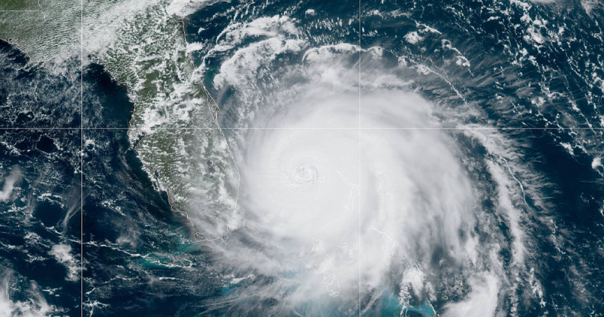
Hurricane Ian is projected to bring a perilous storm surge and winds as strong as 140 mph when it nears Florida’s Gulf Coast in the middle of this week, the National Hurricane Center said on Monday.
Ian strengthened into a major Category 3 storm as of 5 a.m. ET Tuesday, recording maximum sustained winds of 125 mph as it hit western Cuba, forecasters said. Officials in Cuba’s Pinar del Rio province set up dozens of shelters and took steps to protect crops in Cuba’s main tobacco-growing region. The U.S. National Hurricane Center said the island’s west coast could see as much as 14 feet (4.3 meters) of storm surge.
As it hits Cuba, Ian’s storm surge “could raise water levels by as much as 9 to 14 feet above normal tide levels” in some areas, the hurricane center said. The surge is predicted to be slightly less severe in Florida, but parts of Tampa Bay could still see waters 5 to 10 feet higher than normal.
Ian was around 5 miles west of the city of Pinar del Rio, Cuba, moving northwest at 12 mph, the NHC said in its 5 a.m. advisory. “Cuba is expecting extreme hurricane-force winds, also life-threatening storm surge and heavy rainfall,” hurricane center senior specialist Daniel Brown told The Associated Press.
During the next 48 hours, the storm is expected to shift course toward the north and northeast — and the timing of those moves will likely determine where it makes landfall on the U.S. mainland.
A hurricane warning — meaning dangerous conditions are imminent — is in effect for western Cuba. In the U.S., roughly 100 miles of the Florida coast is under a hurricane watch, from Englewood north to the Anclote River — a stretch that includes Tampa, Clearwater, and St. Petersburg. A hurricane watch is normally issued 48 hours before storm conditions arrive.
Ian is the fourth Atlantic hurricane of 2022, a season that only saw its first hurricane earlier this month. So far, predictions of above-average activity in the 2022 hurricane season haven’t come to pass — a circumstance explained by fluctuations in the jet stream and heat waves in northern latitudes.
But Ian’s menacing approach is a reminder of a warning that hurricane experts often invoke: A single bad storm is enough to upend people’s lives.
“It only takes one land-falling hurricane to make it a bad season for you,” Jamie Rhome, the NHC’s acting director, told NPR earlier this month.
Both President Biden and Gov. Ron DeSantis have declared emergencies in Florida, easing the way for federal and state agencies to coordinate their planning and response.
People in Florida are tracking the storm closely
Along the coast of the eastern Gulf of Mexico, all eyes are on forecasts that model Ian’s potential path. But experts urge everyone in the region to have an emergency plan in place, even if the latest track doesn’t show the storm making landfall in their area.
Predictions currently call for the storm to remain off of Florida’s western coast as it moves north toward the Panhandle. But it will drop heavy rain along the way — up to 15 inches in local areas, and 8-10 inches in central western Florida overall.
In areas along the coast, the deepest waters are expected to strike on the storm’s right-hand side, due to the double-whammy of the storm surge and waves whipped by strong winds.
“Regardless of Ian’s exact track and intensity, there is a risk of a life-threatening storm surge, hurricane-force winds, and heavy rainfall along the west coast of Florida and the Florida Panhandle by the middle of this week,” the NHC said on Monday.
Grocery shoppers in the storm’s predicted path are stocking up on water, batteries and other supplies. Some shelves were reportedly bare in northern Florida, but in the Tampa area, residents were more relaxed, hoping the storm will steer clear of them.
“It’s trending west,” a shopper at a Winn-Dixie store in Sarasota told member station WUSF on Sunday. “We have looked at the models and only a few of them look like they are going to impact us, everything else says it is going to be the Panhandle.”
OVERVIEW
OnMyWay Is The #1 Distracted Driving Mobile App In The Nation!
OnMyWay, based in Charleston, SC, The Only Mobile App That Pays its Users Not to Text and Drive.
The #1 cause of death among young adults ages 16-27 is Car Accidents, with the majority related to Distracted Driving.
OnMyWay’s mission is to reverse this epidemic through positive rewards. Users get paid for every mile they do not text and drive and can refer their friends to get compensated for them as well.
The money earned can then be used for Cash Cards, Gift Cards, Travel Deals and Much, Much More….
The company also makes it a point to let users know that OnMyWay does NOT sell users data and only tracks them for purposes of providing a better experience while using the app.
The OnMyWay app is free to download and is currently available on both the App Store for iPhones and Google Play for Android @ OnMyWay; Drive Safe, Get Paid.
Download App Now – https://r.onmyway.com
Sponsors and advertisers can contact the company directly through their website @ www.onmyway.com

OnMyWay is the Only Texting and Driving Solution That Pays
Trusted and 


