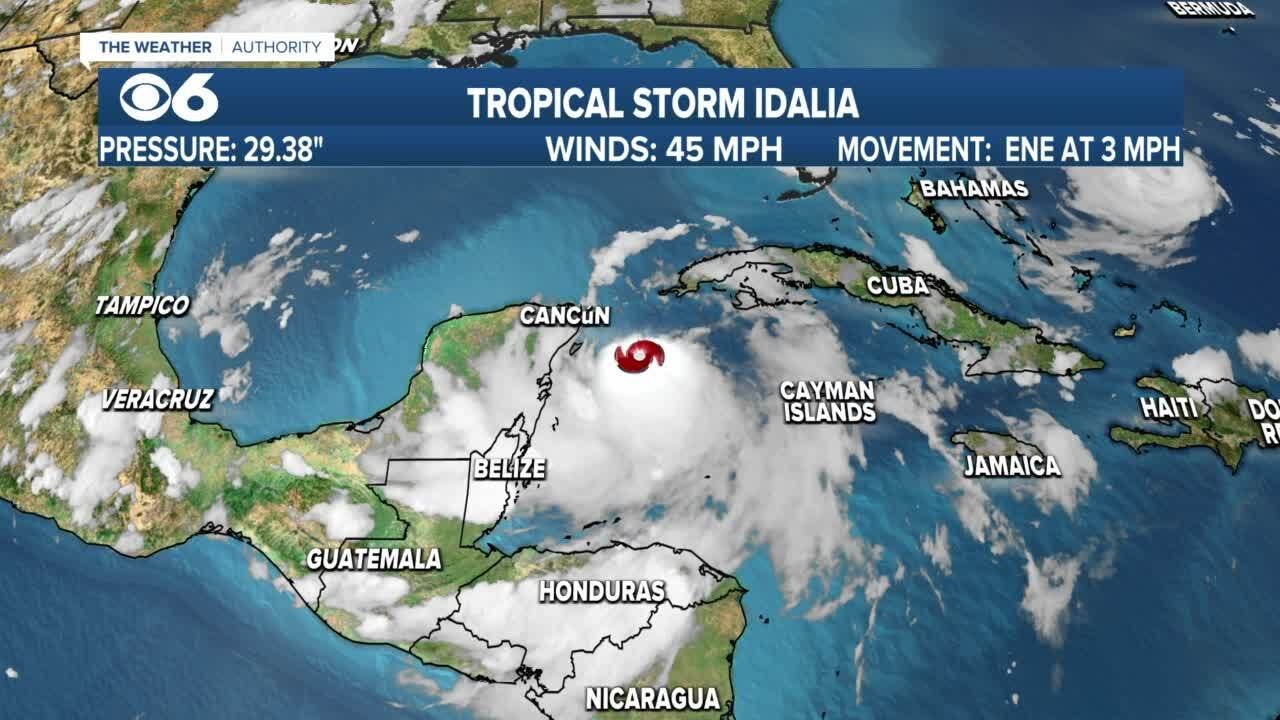
A hurricane watch has been issued for portions of Florida’s Gulf Coast as the state braces for Tropical Storm Idalia, which is expected to strengthen to a hurricane and make landfall this week.
The hurricane watch stretches from Englewood to Indian Pass, including Tampa Bay, according to the National Hurricane Center’s Sunday afternoon update. In addition to the hurricane watch, a tropical storm watch has been issued for the Gulf Coast of Florida from Englewood to Chokoloskee and the Dry Tortugas.
The storm is currently located about 100 miles east of Cozumel, Mexico, moving at around 3 mph with maximum sustained winds of 40 mph, the hurricane center said.
Forecasters predict Idalia will slowly traverse the Yucatán Channel over the next 24 to 36 hours, bringing tropical storm conditions to the far eastern portions of Yucatán, Mexico, and the western tip of Cuba through Monday.
Idalia is expected to make landfall on Wednesday morning near the Big Bend of Florida as a Category 2 hurricane.
“Strengthening is forecast, and Idalia is expected to become a hurricane over the southeastern Gulf of Mexico by early Tuesday,” reads the National Hurricane Center’s update. “Additional strengthening is likely while Idalia approaches the northeastern Gulf coast.
In Cedar Key, a fishing village that juts out into the Gulf of Mexico, a storm surge is among the greatest concerns, said Capt. A.J. Brown, a fishing guide who operates A.J. Brown Charters. The concern is that if the storm strikes Florida just to the north, Cedar Key would get the powerful surge that comes from being on the southeastern side of the storm.
There are worries in Cedar Key about a storm surge of two to five feet of ocean water, Brown said, and if the storm surge reaches five feet “it would cover most everything downtown.”
At the popular Bridge Tender Inn in Bradenton Beach, a large tent covering the tiki bar area where musicians play might have to be taken down in preparation for Idalia, assistant manager Shannon Dunnan said Sunday.
“If we get a big storm that hits, it would probably rip that tent in half,” she said.
But at this point, plans are for the establishment to stay open, Dunnan said.
Mexico’s National Meteorological Service on Sunday warned of intense to torrential rains showering the Yucatan Peninsula, with winds as fast as 55 mph (89 kph).
It said the storm could cause anything from powerful waves to flooding in southern Mexico, mainly around coastal cities in the Yucatán and Quintana Roo states. It asked citizens to stay alert.
Florida emergency officials on Sunday urged residents to keep their vehicle gas tanks at least half-full in case they need to evacuate.
“This will ensure you can evacuate tens of miles inland to a safe location should the need arise,” the Florida Division of Emergency Management said on social media.
Florida has mobilized 1,100 National Guard members, and “they have at their disposal 2,400 high-water vehicles, as well as 12 aircraft that can be used for rescue and recovery efforts,” said DeSantis, the Republican governor who is a candidate for the GOP presidential nomination.
“If you are in the path of this storm, you should expect power outages,” he added. “So please prepare for that, particularly if this storm ends up coming in the Tallahassee region, there’s a lot trees that are going to get knocked down, the power lines are going to get knocked down – that is just going to happen, so just be prepared for that and be able to do what you need to do.”
Thirty-three Florida counties are under a state of emergency, the state emergency management agency said.
So far this year, the U.S. East Coast has been spared from cyclones. But in the West, Tropical Storm Hilary caused widespread flooding, mudslides and road closures earlier this month in Mexico, California, Nevada and points to the north.
The National Oceanic and Atmospheric Administration recently said the 2023 hurricane season would be far busier than initially forecast, partly because of extremely warm ocean temperatures. The season runs through Nov. 30, with August and September typically the peak.
OVERVIEW
OnMyWay Is The #1 Distracted Driving Mobile App In The Nation!
OnMyWay, based in Charleston, SC, The Only Mobile App That Pays its Users Not to Text and Drive.
The #1 cause of death among young adults ages 16-27 is Car Accidents, with the majority related to Distracted Driving.
OnMyWay’s mission is to reverse this epidemic through positive rewards. Users get paid for every mile they do not text and drive and can refer their friends to get compensated for them as well.
The money earned can then be used for Cash Cards, Gift Cards, Travel Deals and Much, Much More….
The company also makes it a point to let users know that OnMyWay does NOT sell users data and only tracks them for purposes of providing a better experience while using the app.
The OnMyWay app is free to download and is currently available on both the App Store for iPhones and Google Play for Android @ OnMyWay; Drive Safe, Get Paid.
Download App Now – https://r.onmyway.com
Sponsors and advertisers can contact the company directly through their website @ www.onmyway.com


