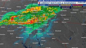
Update: The National Weather Service has expanded the Severe Thunderstorm Watch issued earlier for McCurtain and Red River counties. The watch has been expanded to include the northern half of SW AR and is now in effect until 4 am. The line of storms will begin to move into our area at around midnight and should reach I-30 between 3 & 4 am. Damaging wind will be the main concern with this line as it moves through the area overnight. We will likely see it weaken more rapidly once it begins to move into E TX and NW LA very late tonight.
A warm and humid week and a hot weekend: Despite lots of clouds and some rain around the area, the workweek began with above normal temperatures Monday. Lows Monday morning were in the 60s and lower 70s. Temperatures Monday afternoon have warmed into the low to middle 80s. We likely won’t see much change in our temperatures through Friday. Lows Tuesday morning will likely return to the mid to upper 60s. Highs Tuesday afternoon will return to the low to middle 80s. We likely won’t see much change through Friday. Long-range models are in good agreement that we will likely see the hottest temperatures of the year so far just in time for Mother’s Day weekend. While lows this weekend will remain in the 60s. Daytime highs could soar into the low to middle 90s!
The rain threat continues: Futurecast shows that we will continue to see lots of clouds Monday night and Tuesday. Along with the clouds, look for scattered showers and thunderstorms to move across the area Monday night. Much of Tuesday will be dry with more scattered thunderstorms developing over parts of the area late Tuesday afternoon and Tuesday evening. We will likely see drier conditions for most of the area Wednesday. That will likely change Thursday.
Our next biggest threat of severe weather: Our next best chance for widespread thunderstorms will likely hold off until Thursday and possibly Thursday night. Severe weather including all severe weather threats will be possible. The Storm Prediction Center indicates that we will have a level 2 ‘slight’ risk of severe storms. Once Thursday’s disturbance clears the area, we will likely see several days of dry weather. Below is the outlook for severe weather for our area from tomorrow through the rest of the week.
Rainfall potential: A look at rainfall potential forecasts from several long-range models below shows that two inches of rain would be a reasonable expectation during the next ten days. It is possible that amounts of one to two inches will be possible over the southern half of the area. The vast majority of this rain will fall between now and Thursday.
OVERVIEW
OnMyWay Is The #1 Distracted Driving Mobile App In The Nation!
OnMyWay, based in Charleston, SC, The Only Mobile App That Pays its Users Not to Text and Drive.
The #1 cause of death among young adults ages 16-27 is Car Accidents, with the majority related to Distracted Driving.
OnMyWay’s mission is to reverse this epidemic through positive rewards. Users get paid for every mile they do not text and drive and can refer their friends to get compensated for them as well.
The money earned can then be used for Cash Cards, Gift Cards, Travel Deals and Much, Much More….
The company also makes it a point to let users know that OnMyWay does NOT sell users data and only tracks them for purposes of providing a better experience while using the app.
The OnMyWay app is free to download and is currently available on both the App Store for iPhones and Google Play for Android @ OnMyWay; Drive Safe, Get Paid.
Download App Now – https://r.onmyway.com
Sponsors and advertisers can contact the company directly through their website @ www.onmyway.com.


