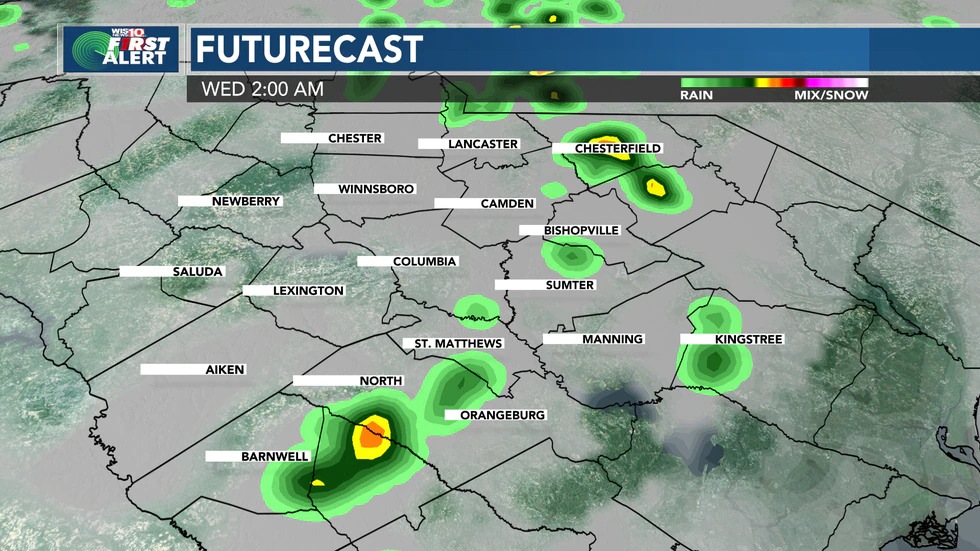
Tonight is a First Alert. A Tornado Watch is in effect for parts of the Midlands until 2 a.m. That means conditions are favorable for tornadoes to develop.
Rain chances are around 50-60% tonight. Otherwise, we’ll see mostly cloudy skies. Lows will be in the mid 70s.
· We’ll see a few scattered showers and potentially some storms Wednesday. Rain chances are around 30%. Showers could develop in the morning, then again in the afternoon for parts of the Midlands. Highs will be in the low 90s.
· Storms are possible Thursday and Friday. Storm chances are around 30% Highs will be in the low 90s.
· We’re tracking more activity in the tropics. Grace will not impact South Carolina at this time. Henri will create a high threat of rip currents at SC beaches.
It’s been an active day in the First Alert Weather Center. We’ve seen several severe thunderstorms, including several tornado warnings and reports of damage in the Midlands.
A lot of this activity is a product of Fred’s moisture moving through the Midlands along with the daytime heating and windy conditions.
A Tornado Watch continues for part of the Midlands until 2 a.m. Wednesday. That means that conditions are favorable for tornadoes to develop. Stay weather aware tonight.
Rain chances are around 50-60% tonight. Otherwise, expect partly to mostly cloudy skies. Some patchy fog is possible. Overnight low temperatures will be in the mid 70s.
For now, Wednesday features about a 30% chance of showers and storms, especially early in the day. A few showers and storms could develop again in the afternoon, but at this point, we don’t expect a severe weather outbreak. We’ll keep you posted. Otherwise, expect partly cloudy skies. Highs will be in the upper 80s.
A few showers and storms are possible Thursday and Friday. Rain chances are around 30% Thursday and Friday. Highs will be in the low 90s.
Some showers and storms are possible this weekend. Highs will be in the low 90s.
We’re also keeping an eye on the tropics. Tropical Storm Grace will continue to track west through the Caribbean and into the Gulf of Mexico. Grace will not impact South Carolina.
Tropical Storm Henri is located in the Atlantic Ocean. The system is not expected to directly impact South Carolina. But there will be a heightened threat of rip currents for South Carolina beaches for the next several days.
First Alert Tonight: Mostly Cloudy. Chance of Showers & Storms (50-60%). Low temperatures in the mid 70s.
Wednesday: Partly Cloudy. A Few Scattered Showers/Storms (30%). Highs in the upper 80s.
Thursday: Partly to Mostly Cloudy. A Few Storms (30%). Highs in the low 90s.
Friday: Partly Cloudy. Chance of Showers/Storms (30%). Highs in the low 90s.
Saturday: Partly Cloudy. Chance of Showers/Storms (30%). Highs in the low 90s.
Sunday: Partly Cloudy. Isolated Storms (20%). Highs in the low 90s.
Monday: Partly Cloudy. Isolated Showers/Storms (20%). Highs in the low to mid 90s.
Tuesday: Partly Cloudy and Hot. Highs in the low to mid 90s.
OVERVIEW
OnMyWay Is The #1 Distracted Driving Mobile App In The Nation!
OnMyWay, based in Charleston, SC, The Only Mobile App That Pays its Users Not to Text and Drive.
The #1 cause of death among young adults ages 16-27 is Car Accidents, with the majority related to Distracted Driving.
OnMyWay’s mission is to reverse this epidemic through positive rewards. Users get paid for every mile they do not text and drive and can refer their friends to get compensated for them as well.
The money earned can then be used for Cash Cards, Gift Cards, Travel Deals and Much, Much More….
The company also makes it a point to let users know that OnMyWay does NOT sell users data and only tracks them for purposes of providing a better experience while using the app.
The OnMyWay app is free to download and is currently available on both the App Store for iPhones and Google Play for Android @ OnMyWay; Drive Safe, Get Paid.
Download App Now – https://r.onmyway.com
Sponsors and advertisers can contact the company directly through their website @ www.onmyway.com.